Physical Address
304 North Cardinal St.
Dorchester Center, MA 02124
Physical Address
304 North Cardinal St.
Dorchester Center, MA 02124


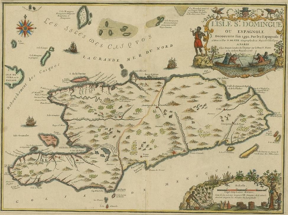
The image above is a rare and invaluable historical artifact: a French colonial map titled “L’Isle St. Domingue”, created in 1749 by cartographer Robert de Vaugondy. At first glance, it might look like a typical old map, but in truth, this is a visual document of the most explosive, transformative, and misunderstood chapter in the Western Hemisphere—the origins of the Haitian Revolution.
This map offers a critical window into the colonial infrastructure, geographic divisions, and economic priorities of the French colony of Saint-Domingue, the precursor to modern-day Haiti. To study it is to walk back in time—into the powder keg of slavery, sugar wealth, and Black resistance that birthed the world’s first Black republic.

This 1749 map wasn’t just a navigational aid—it was a political instrument. Designed by French geographer Robert de Vaugondy and commissioned under royal authority, it laid out the plantations, ports, rivers, and trade routes that formed the backbone of France’s wealth in the Caribbean.
Saint-Domingue was France’s most lucrative colony. By the mid-18th century, it was producing 60% of Europe’s coffee and 40% of its sugar, all on the backs of enslaved Africans. This map meticulously charts those production centers—particularly in the western and northern plains around Le Cap (Cap-Français, now Cap-Haïtien), which was the commercial heart of the colony.
In essence, this map is a blueprint of exploitation.

Though the entire island of Hispaniola is shown here, note how much more detail is given to the western part—the French side, Saint-Domingue—compared to the eastern Spanish side, Santo Domingo.
The Spanish side appears sparse, with fewer towns and features, reflecting its secondary economic status at the time. This imbalance hints at a geopolitical truth: by the 1700s, France had eclipsed Spain as the dominant colonial power on the island, even though Spain had colonized it first.
The border that would one day divide Haiti and the Dominican Republic was already taking shape, not in ideology but in economic focus and imperial ambition.

Notice the coastal cities: Le Cap, Port-de-Paix, Les Cayes, and Port-au-Prince (then a rising settlement). These were not just trade centers—they were heavily militarized colonial hubs fortified to suppress revolts and protect cargo ships full of sugar, coffee, and enslaved laborers.
The map reveals a calculated design: French colonialism depended on a tightly controlled triangle of plantation zones, ports, and patrol routes. But these same chokepoints would later be flipped into revolutionary strongholds when the enslaved population rose up in 1791.
Understanding the geography of oppression helps us understand how the Haitian Revolution was even logistically possible. The very infrastructure built to control enslaved people became the path to liberation.

What’s missing from this map speaks volumes. You won’t find the locations of the massive African slave quarters, maroon communities (escaped slave settlements), or the demographics of who actually lived on this land. By 1749, more than 90% of the population in Saint-Domingue was African or Afro-descended. Yet this map centers the geography of French elites, not the millions toiling under a brutal slave system.
However, historians know that behind every plantation name on this map were thousands of enslaved people, many of whom were just one generation removed from West Africa—retaining military skills, spiritual systems, and organizational knowledge. These invisible lines between fields, forests, and mountains would soon ignite into warpaths of revolution.

The mountainous landscape depicted here played a decisive role in Haiti’s future. The rugged interior—especially the Massif de la Selle and Chaîne des Matheux—provided sanctuary for rebel fighters and maroons.
French troops, unfamiliar with the terrain and burdened by supply lines, struggled to suppress revolts. Meanwhile, Haitian revolutionaries—guided by leaders like Toussaint Louverture, Jean-Jacques Dessalines, and Henri Christophe—used this geography to their tactical advantage, launching raids, evading capture, and staging guerrilla campaigns.
This “land of high mountains” (Ayiti, in the Taíno language) proved to be more than just a name—it was a shield and a sword for the revolution.
Maps shape memory. This one offers us more than coordinates; it tells a story of how a colony designed for profit and domination became the ground zero of Black liberation. It forces us to confront the legacy of imperial cartography and reclaim the narrative from the enslavers to the enslaved.
For modern Haitians and the global African diaspora, this map is not just an antique—it’s an archive of courage. Every line is a prelude to rebellion. Every port is a reminder of stolen bodies and stolen labor. And every town name is a testament to a people who refused to die quietly.
The “L’Isle St. Domingue” map represents a colonial dream that would ultimately collapse under the weight of its own inhumanity. What began as a French crown jewel turned into the world’s first Black republic in 1804—just 55 years after this map was published.
As we study this artifact today, let us redraw it in our minds: not as a French possession, but as the land of Ayiti—fierce, free, and unyielding.